
by Edgar J. Lavoie ©
1 ̶ From Swamp to Shaft
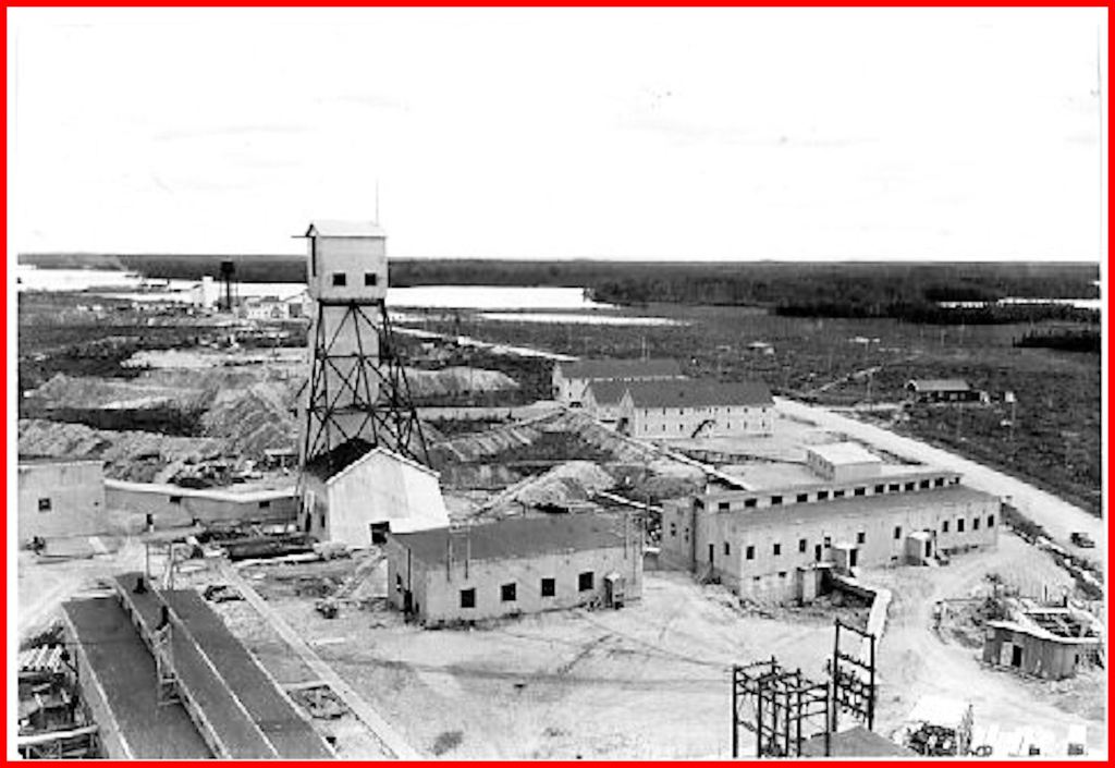
The single most important mining monument in Northern Ontario is being demolished. The No. 1 headframe of the old Macleod-Cockshutt mine was erected in 1937, and is still standing on April 16, 2022, but only for a few more hours.
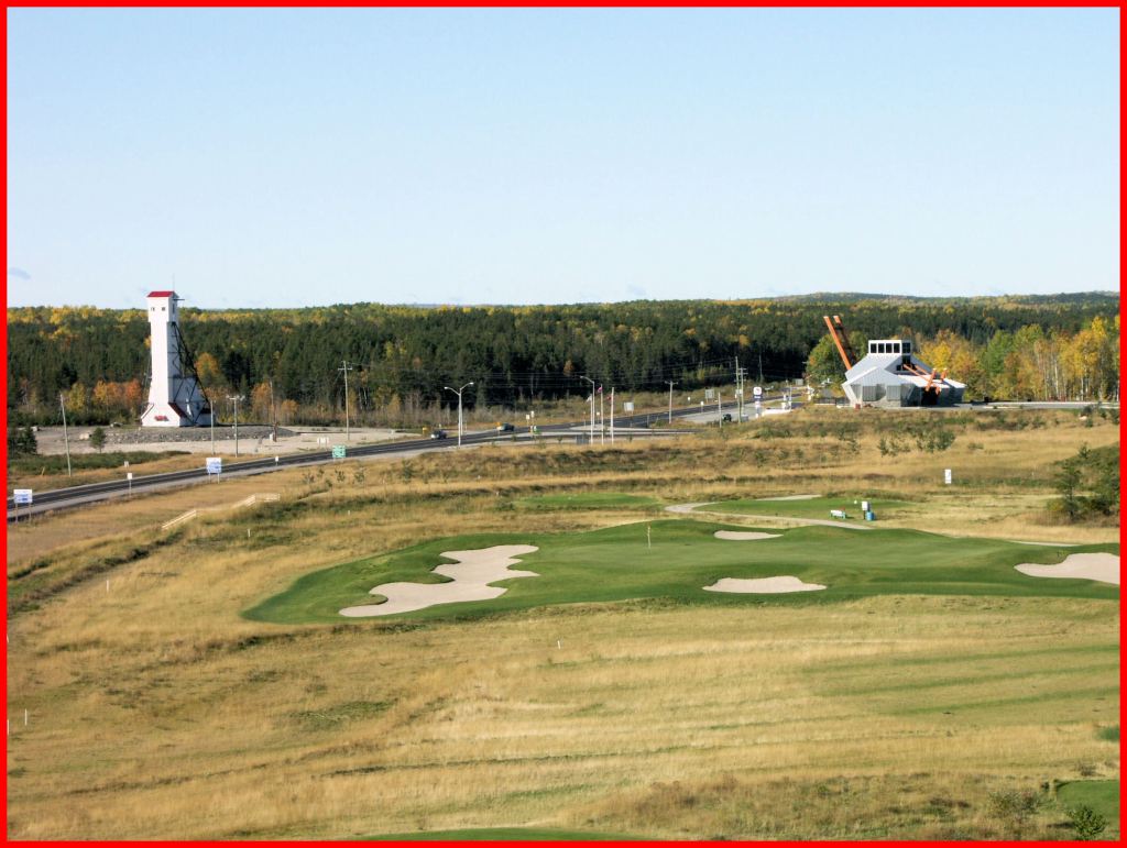
It stands at the junction of Hwy. No. 11 and Michael Power Boulevard (aka Hwy. 584) in the heart of the Little Long Lac Goldfield at Geraldton. The property was staked in the late summer of 1931 by Fred Macleod and Arthur Cockshutt.
The gold property directly east of it was discovered in August 1931 by “Hard Rock” Bill Smith on Kenogamisis Lake (aka Little Long Lake). Smith told his prospecting colleagues, Macleod and Cockshutt, to come running, and advised them to tie on to his property to the west.
Macleod and Cockshutt staked 17 claims. It was rather unimpressive moose pasture. The following summer, Tom Johnson and Tony Oklend discovered what became the famous Little Long Lac gold mine. Macleod and Cockshutt formed the Little Longlac Exploration Syndicate, did some surface trenching on the claims, which were about a mile away, but found nothing to excite them. Maud Gascon staked adjoining claims.
In 1933, surface exploration continued. Macleod-Cockshutt Gold Mines Limited was incorporated in September, acquiring 17 claims owned by the Syndicate, and 5 claims owned by Gascon. The mine took its name from the two discoverers, Fred MacLeod, now president, and Arthur Cockshutt, one of the directors. The 22 claims were optioned to the Connell Mining and Exploration Company, which conducted trenching, pitting, and diamond drilling.
In 1934, a vertical, three-compartment shaft was sunk to a depth of 172 feet, with the first level at 150 feet. At this level, 1,782 feet of drifting and crosscutting was performed. A drift is a tunnel at right-angles to the shaft, and a crosscut is a tunnel at an angle to the drift. Underground exploration failed to produce results and operations were suspended.
In 1935, again diamond drilling and surface exploration failed to get results, and operations were suspended.
In 1936, the almost-new No. 1 headframe was annihilated.

2 ̶ The Geraldton Fire of 1936
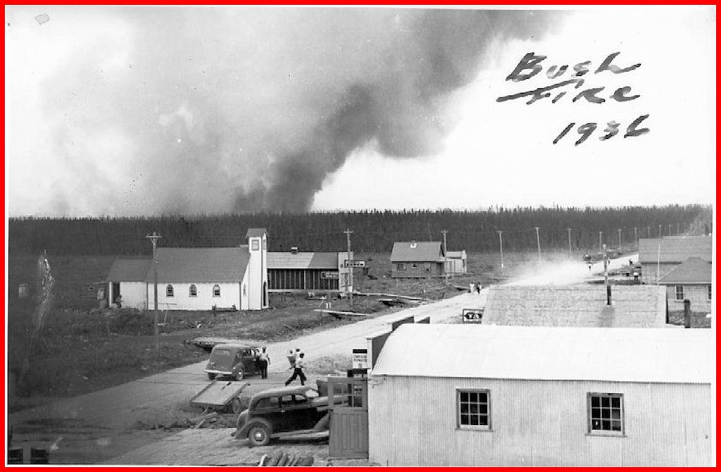
The summer of 1936 was hot and dry all across North America. As July began, a heat wave swept eastward from the prairies, encompassing cities and farms and forests. Crops burned up in the fields. Wildfires broke out in the Northern Ontario bush. People succumbed to heat prostration.
On July 4, George Reesor, chief ranger stationed at Longlac, received reports of fires. At 8:00 a.m., one was reported just southwest of Geraldton, 4 miles from the Macleod-Cockshutt mine; another fire started just east of the townsite near the railway. At 1:00 p.m., Bawk Tower, northeast of Geraldton, phoned in another report. These fires together became known as the Geraldton Fire.
On July 5, a spark from the Bankfield fire leapt 4 miles and ignited the bush on the Macleod-Cockshutt property. Men and pumps extinguished the blaze after it had burned 25 acres. Winds pushed the fire north and east, threatening the Little Long Lac, the Macleod-Cockshutt, and the Hard Rock mines.
On July 7, scores of workers doused buildings at the MacLeod townsite and the mine. Flames claimed the headframe and several buildings. At the time, workers were also engaged in sinking the No. 2 shaft, and managed to save the new buildings including bunkhouses, office, power plant, dry room, and blacksmith shop. Taxi trucks took women and children southeast to the Hard Rock mine on the shore of Kenogamisis Lake.
A report in the Fort William Daily Times-Journal described the harrowing scene: “The wall of flame, 40 and 50 feet high, tossed burning trees and shrubs up to the mine clearing. Clustered around the No. 1 shafthead, the original buildings on the property smouldered. Some burst into flames. Wild rabbits fled before the lung-scorching, gale-force wind and mingled with the crowd. The men fought with water bags and hand-pumps and hoses.”
Women and children at the Hard Rock mine stood by ready to evacuate. Men loaded equipment and household effects on barges and covered them with asbestos sheets.
The wind veered eastward, and everyone breathed easier. The evacuees rested that night on mattresses and blankets, studying the ruddy glare in the heavens.
Several more dramas played out at the Little Long Lac mine and the Geraldton townsite. The fire wiped out Maud Gascon’s village at Hardrock station, east of the townsite. Finally, on July 16, rain began to fall and temperatures began dropping. On July 24, the Ontario Forestry Branch declared the crisis over.
3 ̶ Deeper and Richer
In June 1936, the company began sinking its No. 2 shaft, a vertical, four-compartment shaft, reaching a depth of 532 feet, with levels established at 200 feet, 350 feet, and 502 feet. Underground development proceeded.
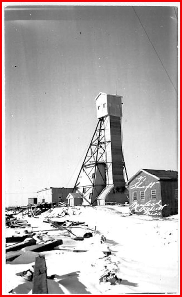
A mining report for 1938 documents activity in the No. 1 shaft, which was still 172 feet deep. The report states 2,010 feet of drifting and crosscutting occurred at the 150-foot level. This activity means that the No. 1 headframe had been rebuilt by the year 1938. An historic photograph shows the MacLeod-Cockshutt property in December 1937. The new No. 1 headframe stands in lonely isolation in contrast to the No. 2 headframe and the cluster of infrastructure. The No. 1 is the headframe which stands at the junction of Hwy. 11 and Michael Power Boulevard.
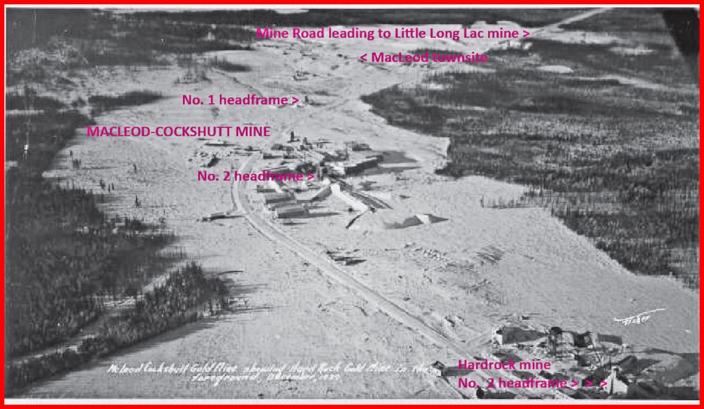
From 1936 onward, the No. 2 shaft was the most active. It stood 1,500 feet east of the No. 1. Around it would cluster key structures such as a power house, hoist room, boiler house, powder magazine and cap house, crusher house, a 50,000-gallon steel water tank, roaster building, a 225-foot stack, shops, and ore bins.
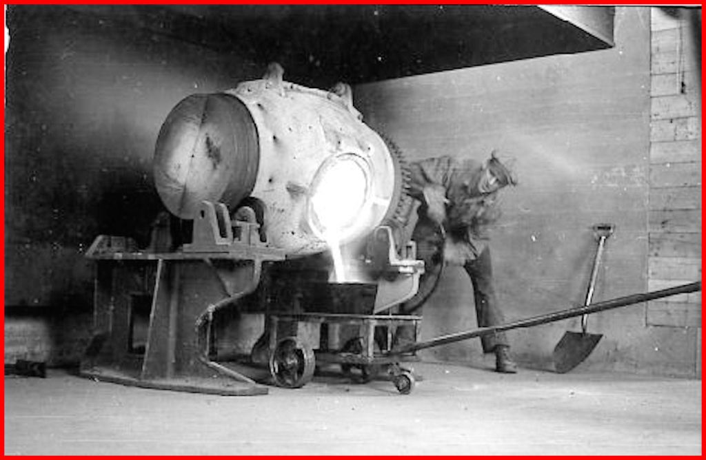
On May 19, 1938, the Macleod-Cockshutt mine poured its first gold brick, valued at more than $70,000. The mine thus became the fourth producer in the Little Long Lac Gold Area. In 1938, the mine produced 25,518 ounces of gold and 1,602 ounces of silver. Gold was valued at approximately $35 per ounce; silver, at around $0.50 per ounce.
In 1940, the No. 1 shaft was deepened to 572 feet, with new levels at 350 and 502 feet. The No. 2 shaft reached the depth of 1,135 feet. In 1941, the No. 1 was extended down to 1,135 feet, with new levels, and the No. 2 reached 1,440 feet, with new levels. The two shafts were connected at the 502-foot level and the 1,108 level. A crusher was installed at the 1,271 level. The No. 1 became officially an auxiliary shaft. The mill’s capacity was expanded.
Over the next few years, the No. 1 was deepened, reaching 2,250 feet in 1957, and an underground crusher was installed at 2,051 feet. The No. 2 shaft had reached 1,921 feet.
In 1958, Little Long Lac Gold Mines Limited acquired control of the mine as well as Consolidated Mosher Mines Limited, to the west of the Macleod. In 1960, the two mines were connected underground. Macleod began treating the ore from Mosher as Macleod’s ore zones became depleted. In 1967, MacLeod-Cockshutt Gold Mines Limited and Consolidated Mosher Mines Limited and Hard Rock Gold Mines Limited were amalgamated to form MacLeod Mosher Gold Mines Limited.
The MacLeod Mosher mine began operating on a salvage basis. In December 1968, Lake Shore Mines Limited (controlled by Little Long Lac mine) took over, creating the MacLeod Mosher Division of Lake Shore Mines Limited.
From 1938 to 1970, the mine had produced 1,546,980 ounces of gold and 108,185 ounces of silver.
There is no figure available for the three subsequent years of clean-up operations.
4 ̶ The Second Fire
After 1970, the No. 1 headframe stood in lonely, shabby splendor. One would have to travel to Red Lake or to Timmins to find another historic headframe. The night of May 29, 2000, changed that.
At 9:40 p.m., the Geraldton Volunteer Fire Department was called out to extinguish a blaze ignited during construction activities. Firefighters entered the 100-foot structure and fought the flames from above. They moved hoses up ladders in the dark, plagued by smoke. Wind drove the fire up the structure like a chimney. Other fighters enlisted an on-site hydraulic lift and fought the fire from outside.
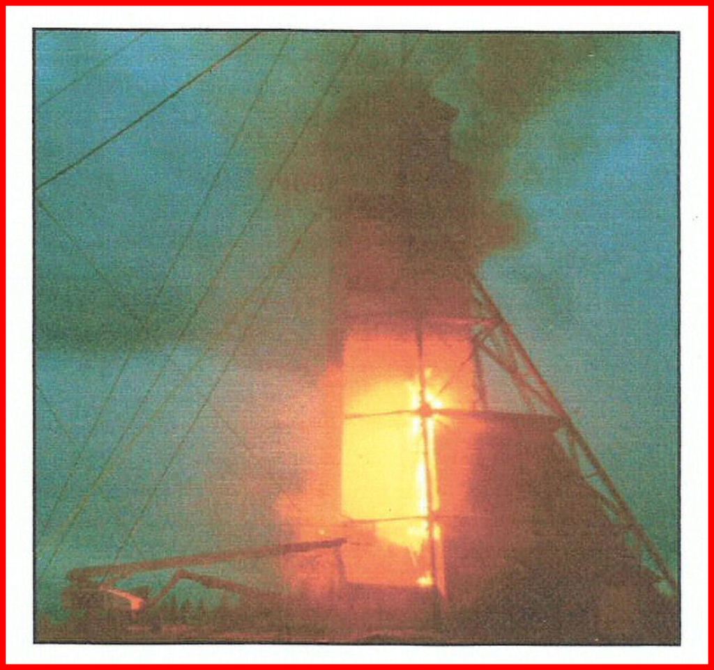
By 2:00 a.m. the fire was declared out. Only the cladding had been consumed. The tinder-dry, grease covered timbers had been preserved. The written response report concluded, “The department is justifiably proud to have been able to save this historic structure so that it may continue to stand as a legacy of our gold mining heritage.”
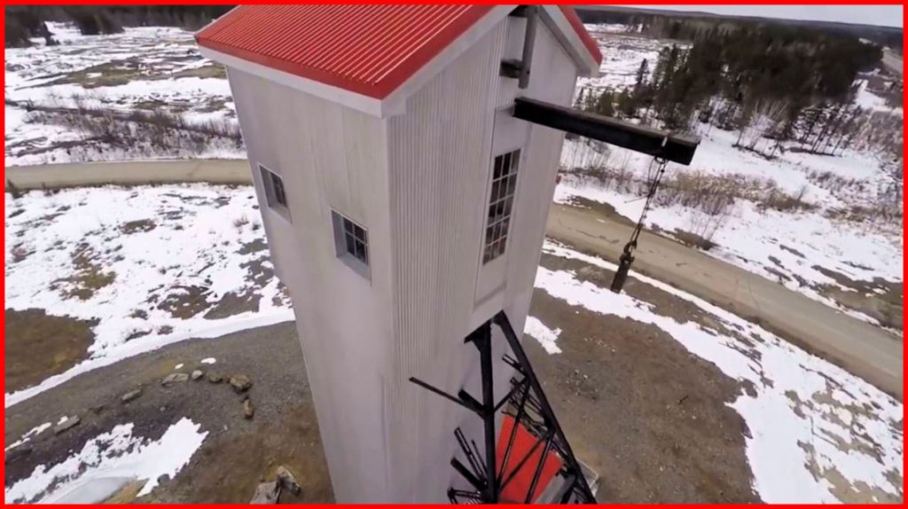
The Municipality of Greenstone soon arranged to restore the headframe (at a cost rumoured to be a million dollars). The red roofing and the silver gray cladding turned the shabby-looking structure into a visual delight.
5 ̶ The Sales
In 2007, Premier Gold Mines began deep-drilling exploration of the Little Long Lac property, and in 2008 extended its operations to the MacLeod-Cockshutt property. Results were so good that the company ordered a feasibility study, and from there, Greenstone Gold Mines GP inc. took over.
The mine development would involve a huge open pit. Municipal assets affected would be the No. 1 headframe, the back 9 holes of Kenogamisis Golf Club (development would encircle the front 9 holes), and the Discover Geraldton Interpretive Centre.
In November 2015, the writer’s blog documented the fate of the headframe: “Stantec Consulting Ltd. has done a Heritage Impact Assessment for Premier Gold Mines Hard Rock Inc. (now operating as Greenstone Gold Mines). Here’s their recommendation for the MacLeod-Cockshutt Mining Headframe listed in Table 3-1:
‘Available mitigation measure: None available as resource is situated within the Open Pit footprint Outcome: Loss of heritage resource including all associated heritage attributes Approach: Restitution in the form of historical information/salvage and commemoration strategy’ “
The notice of sale of these assets came as a complete surprise to most residents of Greenstone. This writer’s blog expressed this surprise: ”On Monday, March 28, [2016] I heard a rumour that the Municipality of Greenstone was going to sell off its assets in the mining zone of Greenstone Gold Mines. Checking it out, I discovered that a regular meeting of Council was scheduled for the very next day! And indeed, the sales of the assets were to be enshrined in by-laws. As usual, there was no notice in the media. It seemed unbelievable that the Municipality would so something of such earth-shaking importance without notice and especially without consulting the voters beforehand in a public arena. I raced to get the notice out to my social media network. There was a lot of feedback and sharing of posts, but the notice was just too late.”
On March 29, 2016, the Municipality held its regular meeting, Mayor Renald Beaulieu presiding. The by-law read: “THAT By-Law 16-22, being a By-Law to enter into an Option to Purchase Agreement between the Corporation of the Municipality of Greenstone and Greenstone Gold Mines GP Inc. for the Headframe be approved for passage and enactment.” In response to a question, Chief Administrative Office Roy Sinclair said that relocation of the structure was cost-prohibitive, but he offered no figures nor details. Discussion elicited the suggestion that the funds be deposited in a special reserve account to replace the assets and not directed to general revenue. There was also the suggestion of a replica headframe with an observation tower. However, no resolutions enacted the suggestions. The by-law passed unanimously. It was all over in 15 minutes and 25 seconds.
The figures for the sales: headframe, $1,435,251; newest 9 holes of the golf course, $3,098,531; interpretive centre, $4,475,372. Total: $9,009,154.
It is worth mentioning that the Internet offers up multiple examples of the relocation of huge legacy structures. The Aswan Dam project in Egypt required the relocation of 22 historical stone monuments. And more recently, the Gwailia gold mine in Western Australia relocated a 118-year old timber headframe and restored it.
The No. 1 headframe could have been moved.

6 ̶ From Shaft to Pit
On October 27, 2021, Greenstone Gold Mines held its ground-breaking ceremony. The Greenstone mine estimated a productive mine life of 13 years. Construction would entail an investment of $1.53 billion for a potential return of 5 million ounces of gold. The price of gold on April 15, 2022, was $1,974.80 USD per ounce.
The open pit will eventually measure 1.8 kilometres long, 1.0 kilometres wide, and 600 metres deep. A small mountain range will be formed from overburden and waste rock.
Of the six ore zones that proved profitable for the MacLeod-Cockshutt mine, the F-zone, the westernmost, yielded the most gold. The open pit will barely tap the F-zone, but sometime in future, the zone may be tapped by underground mining.
In January of last year, Tombill Mines began surface and drilling exploration of its property that abuts the Greenstone mine on the west. The company anticipates an open pit operation to exploit the F-zone extension, and suggests the possibility of an underground operation.
The Little Long Lac Gold Area still has enormous potential. The entire gold area hosted 10 producing mines for a grand total of around 3 million ounces of gold.
As you read this, demolition of the No. 1 headframe is underway. The question is, what legacy landmark will the new mine bequeath to future generations?
[Edgar J. Lavoie is a writer and historian based until recently in the Greenstone region. More of his articles are available on the WordPress platform at E.J. Lavoie’s Blog.]
Drone video from Ryan Wood : (2) Facebook

As it is said, Show me Ruinage, not Cleavage.
LikeLike
The new legacy will be a giant pit and a pile of rock…..
LikeLike