3 ̶ The History
Events in the year 1934 triggered a new era in Jellicoe.
As that year began, Jellicoe was a sleepy railway town in which the most exciting event was the daily arrival of the eastbound train after midnight from Port Arthur and the westbound train in late evening from Longlac. In May 1934, prospector Rene Maloney made a gold strike that woke everybody up, and in June sparked a flurry of news flashes to every part of Canada.
Soon the village of some 60 souls was hosting hundreds of prospectors and a tent city had sprung up. When a Toronto news reporter visited in October, he was astounded. “And now tons of supplies and equipment are pouring into the field by air and water transport, drilling and sinking programmes are proceeding on a score of properties, exploration work is advancing on dozens more, options are being snapped up by old-line gold companies and syndicates, the activity attendant on proving the new field is going into high gear and all is set for a big winter around Jellicoe.”
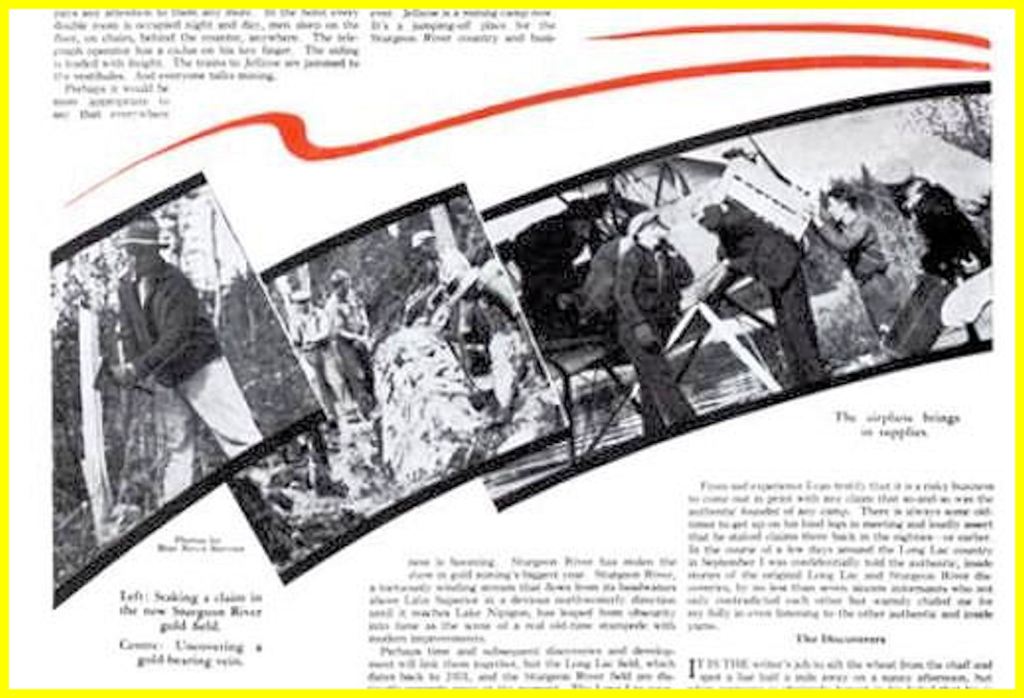
The reporter, Leslie McFarlane, nosed out the circumstances of the discovery. Rene Maloney and Charlie Taylor were prospecting just north of Twin Falls on the Sturgeon River. One day, by arrangement, each went his own way in the search. “Maloney was on his way back to camp that night when he accidentally swung his pick into a clump of moss. It rang like a bell—the ring of steel on quartz. Maloney stripped away some of the moss and uncovered a vein. More moss was tom away. The vein was seven feet wide and well mineralized. He was pop-eyed with excitement, broke off samples and headed, shouting, for camp.”
In spite of the efforts of Maloney and Taylor to suppress it, the news leaked out. Later, Taylor told this story: he and Maloney had launched their canoe just below the Sturgeon Bridge as spring break-up was in progress. They camped at Twin Falls and set out exploring in an area of an old gold find.
Ever since 1915, prospectors had been launching canoes below the falls at the Sturgeon Bridge. This was the shortest and easiest route to the Sturgeon River country. The other route, going upriver from Lake Nipigon, was longer and harder.
Prospectors of the day were a hardy breed. They put in long hours under grim conditions and lived on meagre fare and dreams, lots of dreams. Stories abound about their idiosyncrasies.
Back in 1986, I was researching my history of Geraldton. I heard about this guy (whose name escapes me) batching in Jellicoe who actually knew the late Tom Johnson, the discoverer in 1932 of the Little Long Lac mine.
When I knocked on his door, he was engrossed in preparing his lunch. Ninety percent of the interview was focussed on his making and devouring an enormous raw tomato sandwich. It was a messy business. He did open my eyes, though, to one of the idiosyncrasies of many old-time prospectors. He recalled Johnson walking around his prospects with the neck of an open whiskey bottle clutched in one hand. I’ve never repeated that to anyone, till now.
Bernie Weiler told similar stories. G. Bernard “Bernie” Weiler arrived in Jellicoe in June 1934 and soon after was called to the bar. He acquired the sobriquet “Judge Weiler, the boy lawyer of Osgoode ‘34”. Weiler comes to mind because I asked him to write the foreword to . . . And the Geraldton Way, and he kindly obliged me.
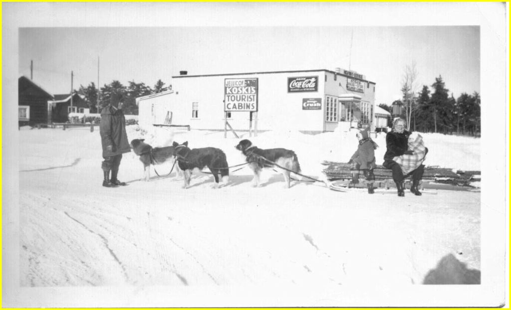
In December 1934, one publication stated: “Two months ago this was Jellicoe [:] the Station, the Restaurant, Ken’s Hotel and small general store alongside comprised the ‘town’.” The article included a list of buildings: Koski’s restaurant; Imperial Bank; Clothing, and General Stores; “Judge” Weiler’s Office; Bridger and Hevenor Stock Brokers; a Laundry; Keto’s Restaurant and Tea Room; Clothing Store; Paquette and McEwen’s Grocery and Meat Store; Allen’s Restaurant; General Store of H.R. McGill; Orenstein & Gardner’s Clothing Store; Speer’s Drug Store; Law Office of J.E. Taylor; Beamish’s Fairway Store; Milton Frances Lumber Co.; the community skating rink; Post Office; Red Cross Outpost Hospital [Railway] Car; offices of Dr. W.J. Henry, Dr. N.H. Hutton, and Dr. W.D. Smith; office of Dr. Ronald Wylie, D.D.S.; Salvation Army; a schoolhouse; a bakery; a newsstand; and several mining company offices.
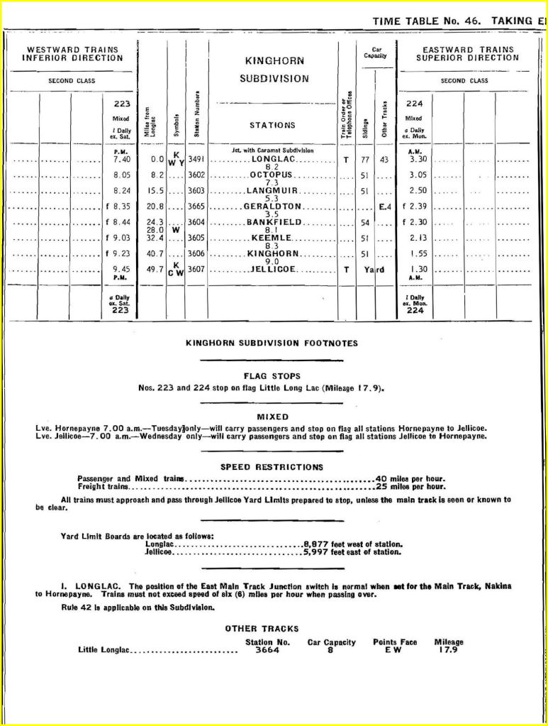
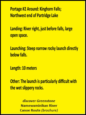
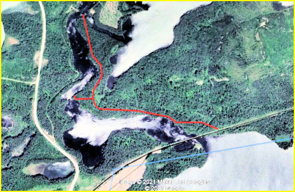
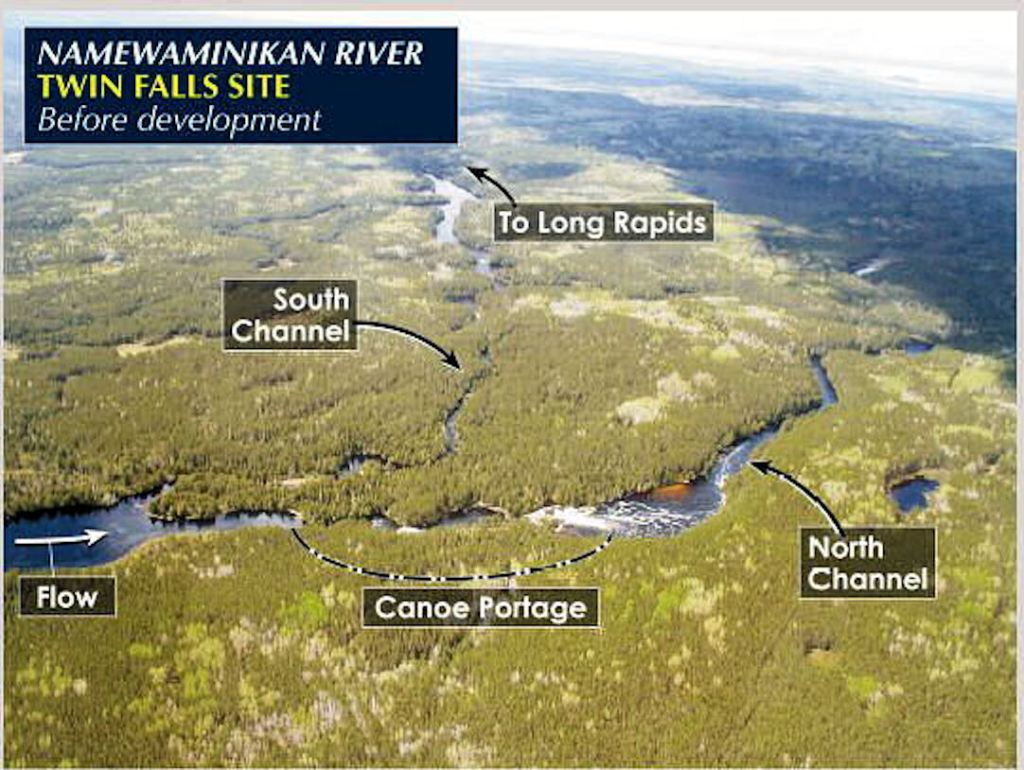
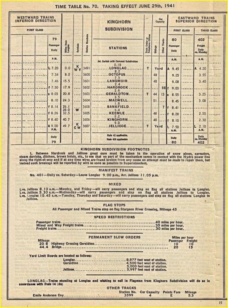
The Sturgeon River bridge, or “The Bridge”, as it was known locally, was precisely 44.4 miles west of Longlac CNR station. The Jellicoe station was 49.7 miles west of Longlac. The Sturgeon River (aka Namewaminikan River) left Partridge Lake and immediately flowed under the bridge. A half mile downstream, the river tumbled over Kinghorn Falls. A walking trail connected the east end of the bridge with the launch site just below the falls.
A Google Earth view of the area reveals an impression of this trail on the right bank, 0.8 km (0.5 mi.) long. The view also shows it extending 0.8 km farther to Lapierre Creek. There is also the trace of a short trail joining the main trail to the portage around the falls. Rob Haslam, a Geraldton resident, recalls leading a party of canoeists downstream from Partridge Lake in mid June 2018 during high water. He found the launch site (called a landing, in canoeist lingo) too treacherous. His party cut a temporary trail on the left bank to the loop road.
Evidence shows that, in 1934, other canoeists used the Lapierre Creek landing as a staging area for travel downriver.
George McDaid used that trail in 1934. On Sunday, November 4, he died tragically. The first news report read in part, “George McDaid, 53, operator of a boarding house at Mileage 45 in the Sturgeon River gold area, a former Port Arthur resident, was killed about 11 o’clock Sunday night, in the Jellicoe yard.”
No one witnessed the train accident which killed McDaid. His body was identified from some letters and papers found near the tracks. The coroner’s jury report read in part, “From the evidence it seems that he was struck while lying between the rails at Mileage 45, east of Jellicoe. No blame can be attached to the crew of the train.” He was survived by his wife, a son, two daughters, two brothers, two sisters, and his mother.
“Mileage 45” is shorthand for the Sturgeon River bridge.
McDaid was killed by Train 223, which timetables establish was a daily westbound mixed train scheduled to stop at Kinghorn at 9:23 p.m. The train was running late, for trainmen testified that the accident occurred about 10:30 p.m. Reading between the lines, one can assume McDaid was waiting after dusk to catch the 223 to Jellicoe, and dozed off.
What was McDaid doing at the bridge? Well, he had staked mining claims in the vicinity earlier in the year and sold them. He had spotted a business opportunity. He had built a boarding house at Lapierre Creek and founded a freighter canoe business there. He would have had a trail from Lapierre Creek on the right bank of the Sturgeon to the east end of the bridge. He was waiting for the train to Jellicoe. His resume included running grocery stores in Nipigon and Port Arthur, and in the Great War, serving with the regiment later called The Cameron Highlanders of Ottawa.
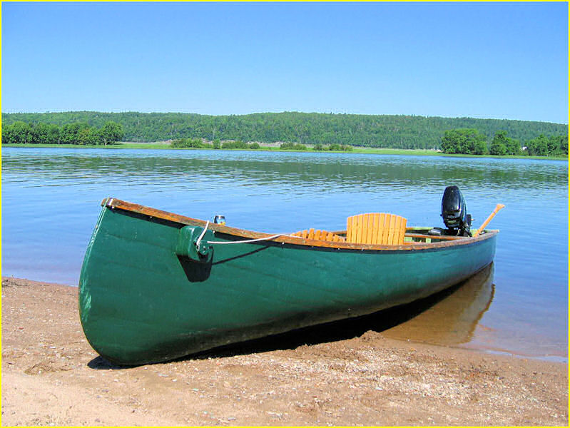
McDaid was not the only one seizing a business opportunity at the bridge. “Peg Leg” Westman and a Mr. Logan did the same. The Globe and Mail reported on September 27: “Westman and Logan are operating a water service down the Sturgeon River. ‘The Bridge’ crosses the Sturgeon about five miles to the east of Jellicoe. There the freight canoes which carry up to 1,200 or 1,400 pounds are loaded. About five of these craft are now being employed, in addition to a number of other smaller ones. The freight canoes, propelled by outboard motors, can make the return trip of thirty miles, loading and discharging canoes, in two days. Most of the properties are near the river, north of south.”
Werner “Peg Leg” Westman was a well-known character in the gold camp. “Peg Leg” had lost a leg at Vimy Ridge. According to Bernie Weiler, “When he got liquored up and was angry[,] he would reach down, take off his wooden leg and brandish it like a baseball bat ̶ but he could travel like a deer through the bush on prospecting trips.”
The Port Arthur and Fort William newspapers gave hints of activities at The Bridge. In mid May 1935, “Eli Cook, operator of a freight and passenger service from Sturgeon Bridge, played to a fishing party from Jellicoe.” The party walked five miles from Jellicoe and boarded two large canoes with Cook as a guide. They coasted as far as Expansion Lake, enjoying the scenery, shooting rapids [nothing serious at this point], and catching 25 pike and pickerel. At the end of the trip, they took the train from The Bridge to Jellicoe. The eight excursionists included G.B. Weiler and R.I. Featherstone [author of the December 1934 news clip?].
Later social notes (as I dub them) identified Cook’s business as Sturgeon River Transportation and then Sturgeon River Forwarding Co. Company employees mentioned by name are Nap Lavergne, Peter StAmand (identified as manager in April 1937), and W. “Bill” Lavelle. All were reported as travelling to and from “Sturgeon Bridge”. The exact location was likely the mouth of Lapierre Creek, where it joins the river below Kinghorn Falls.
In April 1937, Eli Cook was mentioned in another context: “Eli Cook, formerly of the Northland Tractor and Equipment Co. is now with the Sturgeon River Gold Mines.”
In the same month in 1937, at item in the News-Chronicle rated its own dateline:
“PUSH THROUGH ICE IN FREIGHT CANOE ̶ St. Amand Brothers Travel Eighteen Miles Up Sturgeon River to Sand Lake
“JELLICOE, April 28 – Early last weeks two brothers Peter and Wilbert St. Amand, succeeded in travelling eighteen miles up the Sturgeon River to Sand Lake through the ice in a canoe.
“The two men, who are freighters, started out with the idea of seeing how far the open water went. They struck ice at the end of a mile and from there went through ice all the way. The canoe, a twenty-foot freighter with an outboard motor, suffered some damage on the way, but was repaired by the men.
“The trip, they said, was one of the most thrilling they had ever taken. The ice in the eddies of the river several times came near capsizing them, and in one case struck the rear end of the canoe, tearing a hole in it.
“The patching of the hole in the canoe puzzled them for some time. Having not thought of coming that far up the river they had brought no patching supplies with them. A pair of overalls supplied the patch finally, and melted spruce gum from the trees was used to stick it in place.
“At Sand Lake they found the ice piled up where the lake and the two rivers meet to such a height that it would be impossible to get over it even by portaging.
“The whole trip was completed in twenty-four hours.”
The end of April was certainly a very early break-up. The location of Sand Lake is in limbo. Sand Lake gets a mention in a geological report dated 1917, as does Expansion Lake. The sandy beach is referenced, but the exact location is not indicated. Geological reports in the mid 1930s reference lakes below The Bridge, namely, Coral Lake, Expansion Lake, and Paint Lake.
Rob Haslam, veteran canoeist, names lakes with sand beaches between The Bridge and Seven Foot Falls. They are, from east to west, Coral Lake, Petersen Lake, Expansion Lake, and Paint Lake. Expansion Lake meets the criterion of “where the lake and the two rivers meet” because Sturgeon River divides into two channels as it flows around Kingston Island. However, only Paint Lake meets the criterion of distance from the bridge, 18 miles. Yet, by that date, the name Paint Lake was well established.
A social note on April 29, 1937, read: “Peter St. Amand, manager of the Sturgeon River Forwarding Co., is preparing his freighting canoes for a busy season on the Sturgeon River.”
A social note on May 8, 1937 read: “Freighting has commenced on the Sturgeon River. The Sturgeon River Forwarding Co. has acquired a number of new freighting canoes. Pete St. Amand, the manager, has a crew of five who will operate the canoes.” Another note mentions Peter in company with his brother Wilbert.
In September 1938, another person, Tommy Mollison, was identified as residing at Sturgeon Bridge, but no business was associated with him.
Another person frequently mentioned in social notes was Harold R. McGill. McGill set up his Jellicoe store in November 1934 in a tent, employing seven people. He owned the only Delco electric plant in the village. Before winter set in, he had erected a frame building. McGill’s General Store had, by late 1935, established a branch of the store at Sturgeon Bridge at a location called McGill’s Landing.
Between 1935 and 1940, social notes trace the comings and goings of H.R. McGill and his employees, including Arnold Ridley, Edgar Clark, Jack Russell, Jack Carter, Gordon New, and Joe Evans, all working at the branch store at McGill’s Landing. Most employees were temporary workers, but Arnold Ridley stayed on, spending his vacations at the family home in Toronto.
McGill was mentioned as visiting branch stores at Gold Pines and Hudson, and in May 1939, Mr. and Mrs. McGill opened a store in Beardmore. McGill left Arnold Ridley in charge of the Jellicoe Store. The economic reality was that after the gold rush of ’34, business dropped off sharply, and by 1939, Jellicoe reverted to being mostly a sleepy railway town. It is likely that the branch store at McGill’s Landing was severely stressed if it were still operating.
McGill’s Landing got frequent mentions but no location was given. There is a flat, sandy area just metres from the bridge on the south side. In the summer of 2021, five recreational vehicles were stationed there, accessed by a single-lane bush road running west to the ballast pit area. Merchandise might have been offloaded from trains on the south side and ported over such a road. Or, there might have been a bush trail, just metres long, from the west end of the bridge to the “landing”. “Landing” makes sense as a description of this spot, for canoes from upriver could land there, and canoes could carry goods from this spot to the portage around Kinghorn Falls. Also, Kinghorn station was within walking distance of the bridge. A store at his spot would have been convenient for railway section gangs and workers at the sawmill located at Kinghorn station, just 3.7 miles east of the bridge. Social notes mention railway travellers between Kinghorn and Jellicoe.
However, Chapter 4 ̶ The Trails suggests an alternative location for McGill’s Landing.
What is the character of the Sturgeon, aka the Namewaminikan? A 1936 geological report stated: “In parts[,] the Sturgeon river has the character of a well-graded stream strewn with meanders, oxbow lakes, and cutoffs . . . From the rapids below Coral lake the river follows a straight course westward to the east end of Paint lake, but a short distance east of its east end turns sharply northeast and then north, flowing in a broad, shallow valley for a distance of 4 miles to Seven Foot falls. This northerly course is interrupted by only one short rapids where the river crosses a narrow ridge of rock. At Seven Foot falls the river again turns to the west, and a short distance farther down it curves to a southwesterly course.”
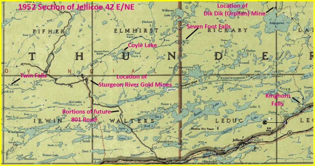
From Seven Foot Falls west to Twin Falls, there were several rapids. A 1936 geological report stated: “Most of [the rapids] are short and can be run by experienced canoemen who know the river . . . “ Access to the area was also possible by flying from Jellicoe.

The same report stated: “The large number of lakes . . . makes airplane service very convenient . . . Goods are landed at Coyle lake, portaged a quarter of a mile north to the Sturgeon river, taken downstream past one rapid, and then portaged to reach the camps of either Sturgeon River Gold Mines or Brengold Mines.”
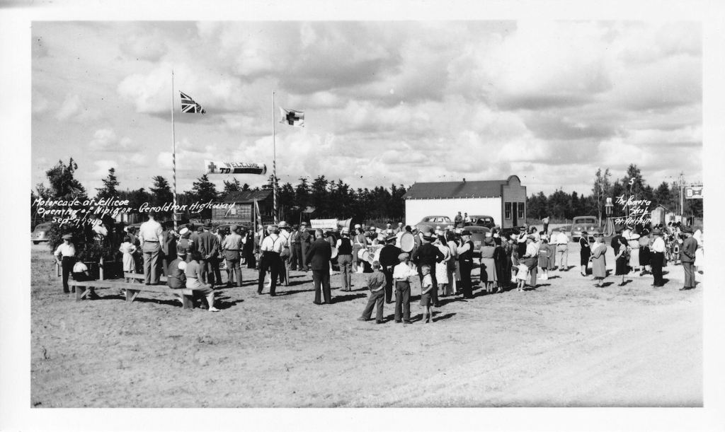
Meanwhile, the Ontario Department of Highways was pushing a road through from Nipigon to Geraldton. In 1940, Geraldton was a busy mining camp, boasting 8 producing mines. The road was Highway 11 and, since construction of the TransCanada, Hwy. 17, was stalled at Schreiber, Hwy. 11 would soon be designated officially as the TransCanada route.
By the summer of ’39, all bridges along the route had been constructed and road work was continuing. On November 7, 1939, the Mayor of Geraldton, Foster Draper, appointed himself to pioneer the new route. He and his “official party” piled into a car and set out for Beardmore, a distance of 50 miles. The trip took 2 ½ hours, after which they turned around and headed home.
According to Geraldton’s official history, in early 1940, “That winter, motorists regularly made the trip between Geraldton and the Lakehead [now Thunder Bay]. At Lake Helen, just north of Nipigon, they found it convenient to detour across the ice. By the first of April, the ice road became hazardous, and the remainder of the Nipigon-Geraldton highway deteriorated with the spring thaw.”
One of the last news items to refer to The Bridge was published on January 29, 1940: “H.R. McGill returned on Saturday from a two weeks’ business trip to Sturgeon River.” McGill was now operating his main store in Beardmore. One is tempted to speculate on the reason for his business trip. According to other social notes, McGill had never spent such a long duration at Sturgeon River. Was McGill closing down his branch store at McGill’s Landing? Was he disposing of his stock and furniture?
On March 5, 1940, there was a cryptic reference to Arthur Ridley among the Beardmore items: “A. Ridley has returned to Jellicoe.” Ridley was managing the Jellicoe store of H.R. McGill. Was Ridley coming from his home in Toronto, or from closing up the Sturgeon Bridge branch store?

Geraldton’s official history describes a time of celebration: “On September 7th, 1940, Highway 11 officially opened. Early Saturday morning, a motorcade left Geraldton accompanied by the Goldfield Band. Around noon in Nipigon, they met a Lakehead motorcade. After some functions there, the combined motorcades stopped in Beardmore for a reception and luncheon, and then in Jellicoe for a ribbon-cutting ceremony. At suppertime, everyone arrived at the town square in Geraldton, where the Hon. T.B. McQuesten declared the highway officially opened.”
In 1940, the Sturgeon River Gold Area was quiet. An all-season motor road provided access to Sturgeon River Gold Mines, the only operating mine. The Dik Dik, aka the Orphan, was mothballed. Kinghorn sawmill had shut down. Freighter canoes no longer plied the river. Regularly, twice a day, a train broke the silence. The village of Jellicoe was nodding off.
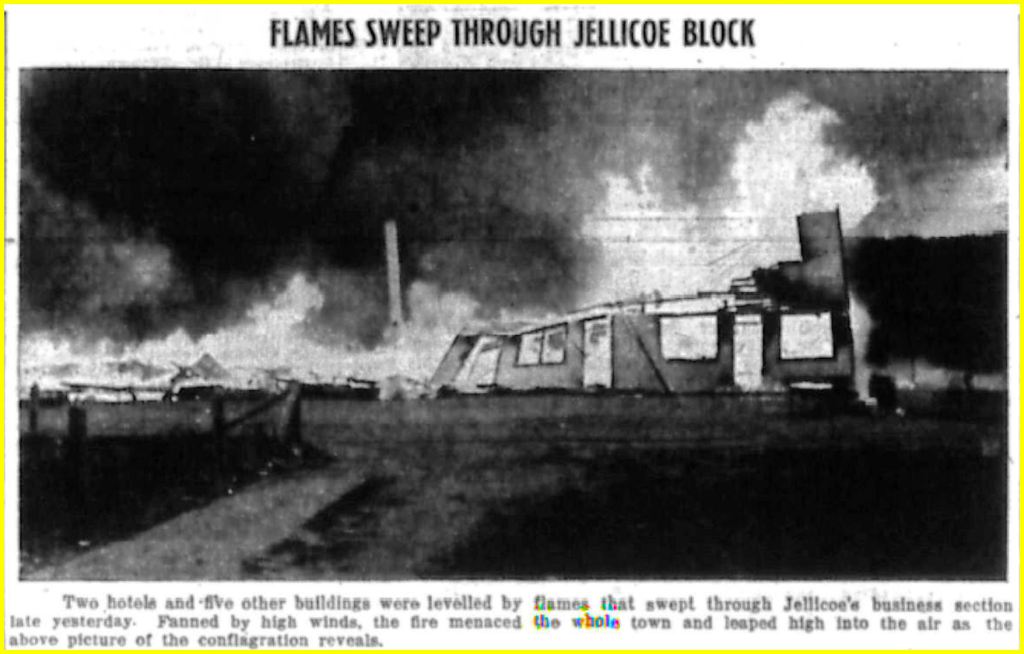
For one long evening in the fall of 1940, the village was shocked awake. About five o’clock on Tuesday afternoon, September 24, a fire broke out in the Allen hotel. A high wind fanned the flames, spreading to the next-door Koski hotel and to five smaller buildings. Soon the entire business block was ablaze.
The Canadian National tank car, stationed in Jellicoe, played a major role in containing the conflagration. The firefighters saved many structures in the village, and battled, successfully, to save the railway station.

In a related article in the Fort William newspaper a week later, a writer pointed out the mining achievements of the past and the promising mining future of the whole region. Within a week, at least three businesses had recovered swiftly: Frank Allen was finishing the remodeling of his other hotel just north of Noble Lake and southwest of his former hotel (the three-storey building?). And “Anti Koski already has a new gas station operating fronting on Spring Lake, and is planning to build a modern tourist hotel directly fronting the highway”.
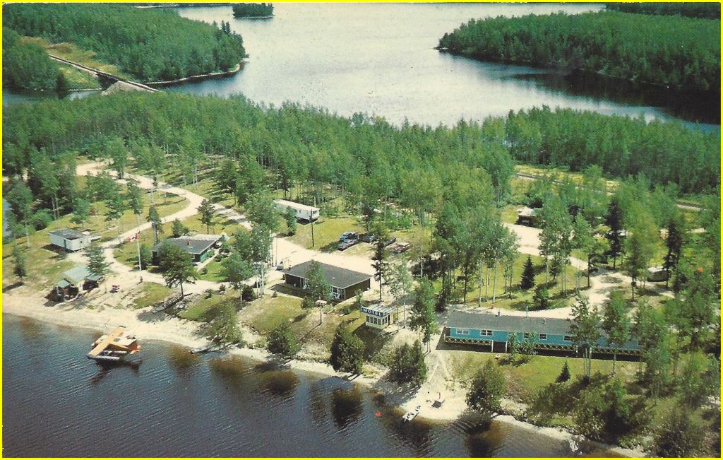
The article continued, “From a tourist and camping standpoint, the new highway opens a bright new outlook for Jellicoe. The town is splendidly situated on a high, dry, and level sand plain, with lakes in the depressions inside the townsite, having natural terraced embankments surrounding the water, that could not be improved upon by the work of man.”
In her book about Jellicoe, Lise Koning records the thoughts and experiences of past and current residents. All have fond recollections and strive to keep in touch.
Koning includes a poem authored by Ben Nelson and titled A Tribute to Rene Maloney. The poem concludes with a long list of pioneers who, with Maloney,
. . . called Jellicoe “home”, and they became its gentry.
So, in time the “Capital of the Sturgeon River Goldfield”, did fade
To become the “sleepy town” that survives yet in this century.
SELECTED SOURCES
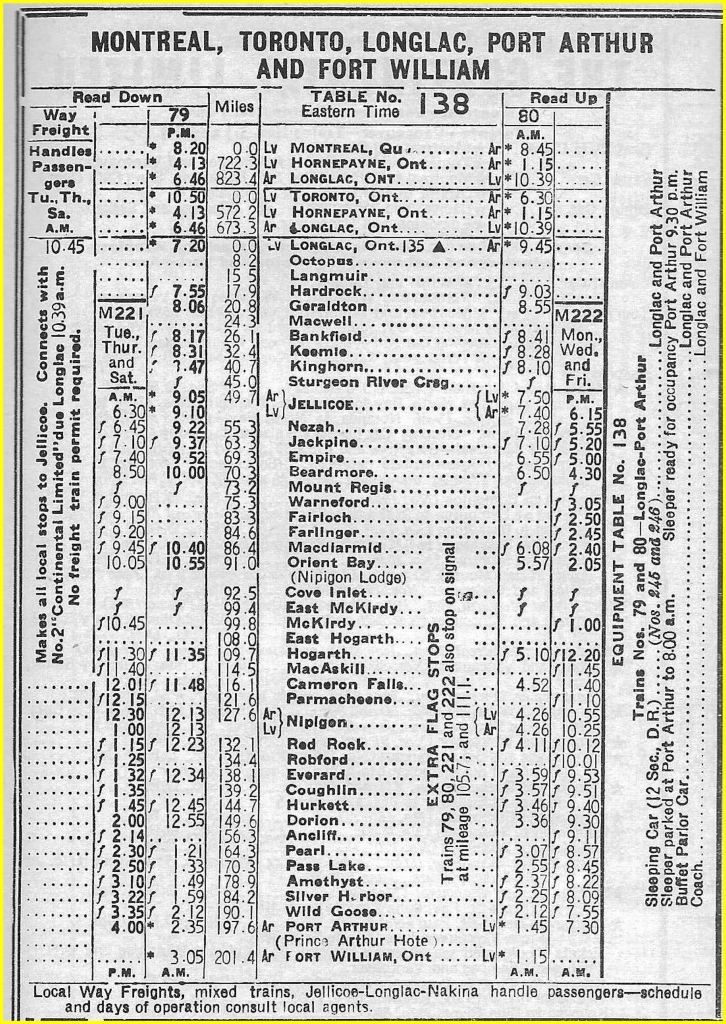
CNR timetables, courtesy of Dave Battistel.
Leslie McFarlane. “The Sturgeon River Stampede”, Maclean’s Magazine, November 15, 1934.
G.B. Weiler. “Some Memories of the Thunder Bay Gold Rush of ‘34”, Papers and Records, Vol. VII, 1980, Thunder Bay Historical Museum Society.
Bob Featherstone. “How Jellicoe Leaped Into Fame Overnight”, December 18, 1934, publication not cited.
Rob Haslam, personal interviews, August 202l.
Leo Furoy, personal interview, September 2021.
Brochure, discover Greenstone : Namewaminikan River Canoe Route.
Port Arthur News-Chronicle newspapers.
Fort William Daily Times-Journal newspapers.
The Globe & Mail newspaper,
Toronto Daily Star newspaper.
1917, Vol. 26, Annual Report, Part 1, ‘Longuelac to Jellicoe and Orient Bay”, Ontario Bureau of Mines.
1936, Vol. 45, Annual Report, “The Eastern Part of the Sturgeon River Area” and “The Western Part of the Sturgeon River Area”, Ontario Department of Mines.
Ben Nelson. Jellicoe: A Description of the Community’s Life to 1937. 2005.
Edgar J. Lavoie, . . . And the Geraldton Way, Town of Geraldton, 1987.
Lisa A. Koning. Where The Heck Is Jellicoe? Jellicoe Recreation Club, 2007.